AM Update (11/11/22) Tropical Depression Nicole | Eastern North Carolina Now

This morning’s update from the National Weather Service included a Tornado Watch for Beaufort County, and made minor changes to the forecasted impacts for our area.

ENCNow
News Release:

    Good Morning Everyone,

    This morning's update from the National Weather Service included a Tornado Watch for Beaufort County, and made minor changes to the forecasted impacts for our area. These changes have been underlined below.

    Rain

  • Rain chances will continue through 4am Saturday, with most areas expected to receive another 1/4 to 1/2 inch of rain as bands continue to move through Eastern NC.
  • Our greatest chance of rain is currently forecasted to occur between 10am and 3pm today, with our heaviest rains expected between noon and 2pm.

    Winds

  • Sustained winds between 10 and 15 mph are expected through 4am Saturday morning, with frequent gust of 25 to 35 mph likely during this time.
  • Our highest winds are forecasted to occur between 1pm today and 2am Saturday.
  • These winds will transition as follows:
  • SE winds between 8am and 7pm Friday.
  • South winds between 7pm Friday and 4am Saturday.
  • SW winds between 4am Saturday and 2am Sunday.
  • West / NW winds after 2am Sunday.

    These transitioning winds will result in brief periods in which water is pushed in to and pulled out of susceptible waterways throughout our county.

    Severe Thunderstorms / Tornado

  • Strong to severe thunderstorms, as well as isolated tornados are possible through 7pm today.
  • A Tornado Watch has been issued for Beaufort County until 3pm.

    Please see the email below and attached briefing from the National Weather Service for additional information. There will be no further updates related to TD Nicole.

    We encourage everyone to ensure that you, your family, friends and neighbors have a way of receiving weather related watch and / or warning notifications. (Alert notifications on your cell phone and other smart devices, weather radios, etc.)

    As always, thank you all for what you do to keep Beaufort County informed, prepared and safe.


    Chris Newkirk
       Deputy Director,     Beaufort County Emergency Services

    1420 Highland Dr
    Washington, NC 27889

      Office: (252)940-6511  •  Cell: (252) 378-5352


    **Tornado Watch in Effect for all of Eastern NC through 3 PM**

    Good Morning Eastern NC Partners,

    Nicole has weakened further to a Tropical Depression as the center of circulation moves northeastward through Georgia. Impacts from the remnant storm are still expected however. The main threat will be the possibility for a few tornadoes today, and a Tornado Watch is in effect for all of Eastern NC through 3PM this afternoon. There may be a break in the showers and storms by late afternoon through early evening, but additional showers with some embedded thunder are possible later this evening before it all moves off the coast late tonight. Activity this evening is not expected to be severe, though some periods of gusty winds in heavier showers are still possible.

    As south winds increase late in the day today, and peak tonight, minor water level rises are possible on the soundside of Hatteras Island north of Buxton to Duck, as well as for Mainland Dare County. A Coastal Flood Advisory remains in effect for these locations from tonight through Saturday afternoon.

    See the attached 2-page briefing for details on the tornado and coastal flood threat.

    If you have any questions, please contact us at (252) 223-5737 Ext. 6.


    Regards,

    NWS Newport/Morehead City


   NOAA - National Weather Service
   Newport/Morehead City, NC Weather Forecast Office
   533 Roberts Rd
   Newport, NC 28570
Go Back


Leave a Guest Comment

Your Name or Alias
Your Email Address ( your email address will not be published)
Enter Your Comment ( no code or urls allowed, text only please )


AM Update (11/10/22) - Tropical Storm Nicole Local News & Expression, The Region North Carolina Food Innovation Lab growing food business in North Carolina


HbAD0

Latest The Region

A Coastal Flood Advisory for our waterways, meaning water levels are expected to be 1 to 2 feet higher than normal.
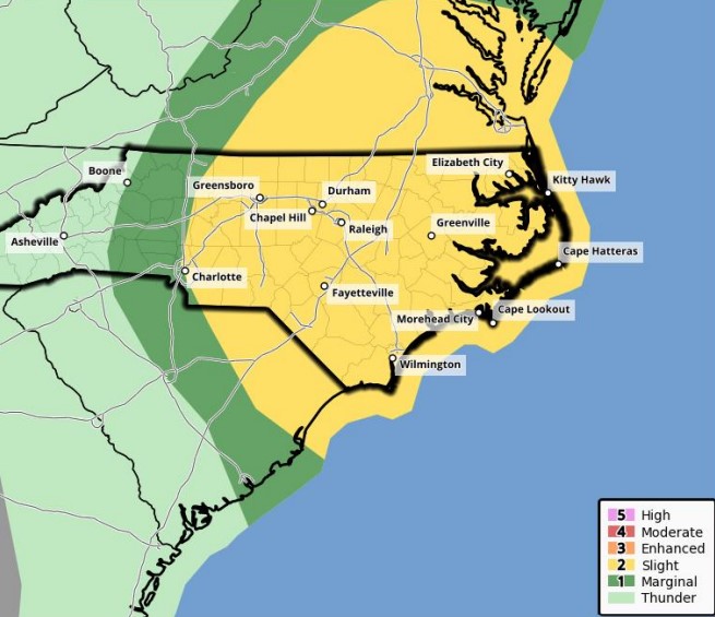
This morning’s update included both good and bad changes for our area, with another reduction in the total rainfall but an increased threat of tornados.
This afternoon’s update included a reduced threat of storm surge for our area, and an increased concern for downriver flooding for areas along the lower Tar River early next week as a result of inland rainfall.
Debby continues to live up to its reputation of being a difficult storm to forecast, and we appreciate everyone’s patience as we navigate these changes in real time.
The afternoon updates have included another increase in expected rainfall amounts, and provided us with additional details related to the timing of our forecasted impacts.
Recent weather updates continue to include minor track and timeline adjustments to Debby’s path along the eastern US, as well as an increase in forecasted rain fall and expected winds for our area.
Recent weather updates continue to include minor track and timeline changes to Debby’s path along the eastern US. Forecast models continue to vary on the where Debby will stall, and the track it will take afterwards.
Recent weather updates included minor timeline changes to Debbie’s track along the eastern US. While forecast models continue to become more aligned, there are still unknown variables that could determine the expected impacts for Beaufort County.

HbAD1

 
Back to Top