News Release:
Good Afternoon Everyone,
This afternoon's update from the National Weather Service has added coastal flooding graphics for the sound side of the Outer Banks and made minor changes to the timing of the forecasted impacts to Beaufort County. These changes have been
underlined below.
A high pressure system will continue to bring sustained NE winds between 10 and 15 mph through
midnight tonight. Frequent gust between 20 and 30 mph are likely through 7pm tonight. These conditions are expected to keep our waterways 1 to 2 feet above normal.
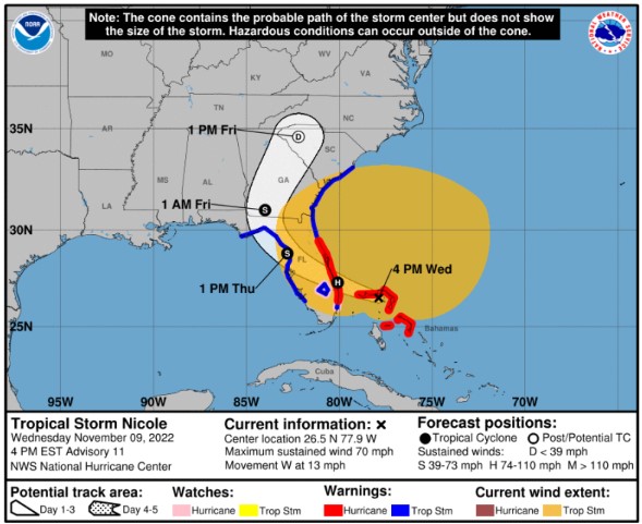
Remnants of Tropical System Nicole is expected to move through North Carolina Thursday night / Friday, impacting Beaufort County as follows.
Rain
- Rain chances begin to increase after 1am Friday morning and continue through midnight, with 1/2 to 1 inch currently forecasted for our area.
- Our greatest chance of rain is currently forecasted to occur between 7am and 7pm Friday, with our heaviest rains expected between 7am and 1pm.
Winds
- Sustained winds between 10 and 20 mph are expected from 7pm Thursday through sunrise Saturday morning. Frequent gust between 20 and 30 mph are likely between 7am and midnight Friday.
- Our highest winds are forecasted to occur between 1pm and 10pm Friday.
- These winds will transition as follows:
- East winds between 8am Thursday and 2am Friday.
- SE winds between 2am and 1pm Friday.
- South winds between 1pm Friday and 2am Saturday.
- SW winds between 2am and 6am Saturday.
- West winds between 6am and 8pm Saturday.
These transitioning winds will result in brief periods in which water is pushed in to and pulled out of susceptible waterways throughout our county.
Severe Thunderstorms / Tornados
- Strong to severe thunderstorms, as well as isolated tornados are possible between 7am and midnight Friday, as bands associated with Nicole move through our area.
Please see the email below and attached briefing from the National Weather Service for additional information. Their next update is scheduled for 6pm today. We will continue to pass along information as we receive it.
As always, thank you all for what you do to keep Beaufort County informed, prepared and safe.
Chris Newkirk
Deputy Director, Beaufort County Emergency Services
1420 Highland Dr
Washington, NC 27889
Office:
(252)940-6511 • Cell:
(252) 378-5352
Good afternoon,
No big changes with this update. We added a different coastal flood graphic with this update to reflect the new areas impacted Friday into early Saturday, as our winds eventually shift from the northeast to the south by Friday.
The next briefing will be sent by 8 AM Thursday morning.
If you have any questions, don't hesitate to contact us at (252) 223-5737 Ext. 6.
Regards,
NWS Newport/Morehead City
NOAA - National Weather Service
Newport/Morehead City, NC Weather Forecast Office
533 Roberts Rd
Newport, NC 28570