Hurricane Florence, Projected to Pound North /South Carolina: Thursday Update, September 13, 2018 - 1 | Eastern North Carolina Now

Hurricane Florence will affect a wide swath of coastal residents in North and South Carolina, currently making landfall as a Category 2 hurricane, in the Cape Fear region of North Carolina, skirting Brunswick County, NC and then Horry County, SC as a Cat 1 hurricane.

ENCNow
    This is a continued series of posts explaining in detail the known whereabouts of Hurricane Florence, its presumed direction, and an accounting of its probable impact.

Hurricane Florence will affect a wide swath of coastal residents in North and South Carolina, currently making landfall as a Category 2 hurricane, in the Cape Fear region of North Carolina, skirting Brunswick County, NC and then Horry County, SC as a Cat 1 hurricane, about 22 miles south of where the storm was initially projected to hit, shown in this first report on Hurricane Florence on BCN.

    Currently, Hurricane Florence is quickly barreling toward shore at about 15 miles per hour, but projected to dramatically slow once it gets close to the South Carolina /North Carolina state line; however, what happens after that landfall is still subject to great change. That being the continual case, BCN is offering the latest information on this one named storm, including each post archived here for current and future reference.

    Please use these resources: 1) Current updates from NOAA (National Oceanic and Atmospheric Administration); 2) current digital map and projected path of storm(s) - in addition to the mapped information below to know Hurricane Florence's most current course, it's possible impact, and to plan for what become a life changing event - a powerful Atlantic Ocean hurricane.

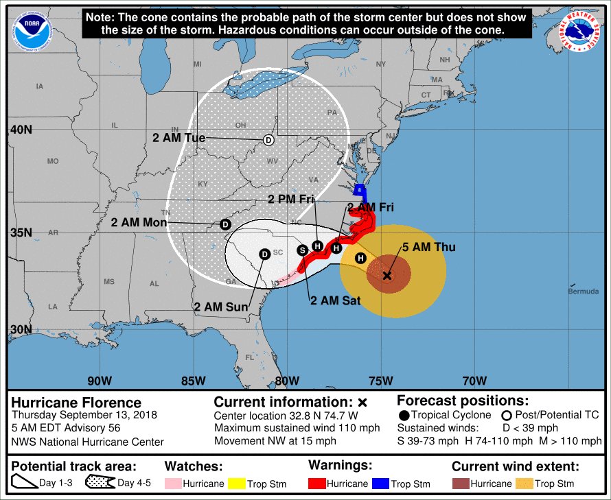
Below: This map of Hurricane Florence suggests the direction, impact point, and estimated time of arrival, as of Thursday, 091318 at 5:00 am.


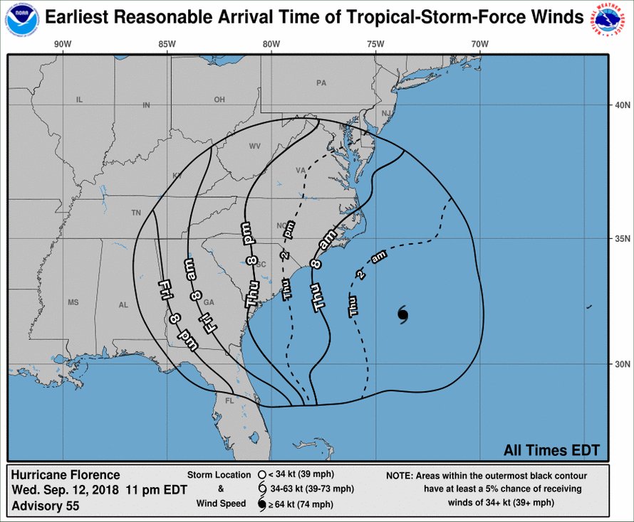
Below: This map of Hurricane Florence suggests the direction, and estimated time of the arrival of the tropical storm force winds within the impacted area, as of Thursday, 091318 at 5:00 am.


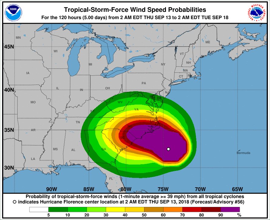
Below: This map of Hurricane Florence suggests the direction, and probability of the arrival of the tropical storm force winds within the impacted area, as of Thursday, 091318 at 5:00 am.


Go Back

HbAD0

Latest The Region

A Coastal Flood Advisory for our waterways, meaning water levels are expected to be 1 to 2 feet higher than normal.
This morning’s update included both good and bad changes for our area, with another reduction in the total rainfall but an increased threat of tornados.
This afternoon’s update included a reduced threat of storm surge for our area, and an increased concern for downriver flooding for areas along the lower Tar River early next week as a result of inland rainfall.
Debby continues to live up to its reputation of being a difficult storm to forecast, and we appreciate everyone’s patience as we navigate these changes in real time.
The afternoon updates have included another increase in expected rainfall amounts, and provided us with additional details related to the timing of our forecasted impacts.
Recent weather updates continue to include minor track and timeline adjustments to Debby’s path along the eastern US, as well as an increase in forecasted rain fall and expected winds for our area.
Recent weather updates continue to include minor track and timeline changes to Debby’s path along the eastern US. Forecast models continue to vary on the where Debby will stall, and the track it will take afterwards.
Recent weather updates included minor timeline changes to Debbie’s track along the eastern US. While forecast models continue to become more aligned, there are still unknown variables that could determine the expected impacts for Beaufort County.

HbAD1

We would like to have quick briefing with our county’s municipal leaders and public safety partners to discuss our response to the potential impacts of Tropical Storm Debby tomorrow, Tuesday 8/6 at 7pm.
Our office is continuing to monitor the development of a tropical system, that is expected to become a named storm (Debbie) within the next 48hrs.
Our office is monitoring the forecast of an approaching front moving through this afternoon that could produce heavy rainfall, isolated strong to severe thunderstorms, strong winds, coastal flooding, and dangerous marine conditions.
In 1920, the American Legion adopted the red poppy as the symbol of remembrance of those who gave their lives in war.
Our office is currently monitoring the forecast of an approaching cold frontal system moving through today through Thursday.
Our office is currently monitoring an increasing risk of severe afternoon thunderstorms over the next three (3) days.
Our office is currently monitoring an approaching weather system that will bring windy conditions, rain, and the potential for strong storms to our area tomorrow.
Our office is currently monitoring the forecast of an approaching cold front that has the potential to bring severe weather to our area tomorrow.
The great misnomer for non Christians that the day Jesus Christ was executed by occupying Romans, celebrated by Christians as "Good" Friday, must be a paradox of ominous proportions.

HbAD2

 
Back to Top