
Our Community Platform providing Essential Information to Know what is Real


I'm back online, and fortunately still alive.


Publisher's Note: As a county commissioner of the county of Beaufort, I have access to the Beaufort County Emergency Management Operation and Control Center which conveniently is a short walking distance from my house. Otherwise, I have no power, no internet, no access to a passable road, and I literally possess a most remarkable odor. Just part of my scene here in eastern North Carolina.
What may be the worst hurricane in the last 56 years (since Hurricane Hazel in 1954) has released its horrendous grip on the county I call home - Beaufort. I have endured as many of us have, but I do not remain unscathed.
Washington, North Carolina, looks like a war zone. Aurora, N.C., because of its geographic proximity to the ever-lingering eye wall (estimated at 40 to 45 miles wide, with the eye of this monster storm estimated from 30 to 35 miles wide) of Hurricane Irene, may well have taken Beaufort County's biggest hit. It is arguably, along with Belhaven, N.C., Beaufort County's lowest-lying municipality. Aurora's flood plain is about seven or eight feet. They took a storm surge of over 11 feet of Pamlico River, or more likely Pamlico Sound and Atlantic Ocean, water. If Aurora took three to four feet of water at its highest point, can you imagine how much water filled the lowest point. The culprit: Hurricane Irene's prevailing hurricane-force winds from the northeast hitting this low-lying hamlet that faces northeast.
The storm surge was so strong and the sustained winds so powerful in the eye wall that at one point four cottages - in a row - were seen floating down the Pamlico River. This information was reported to the Beaufort County Emergency Management Operation and Control Center by a resident who road out the storm from his home at Hickory Point (north from the battered Town of Aurora at the mouth of South Creek, where it empties into the Pamlico River).
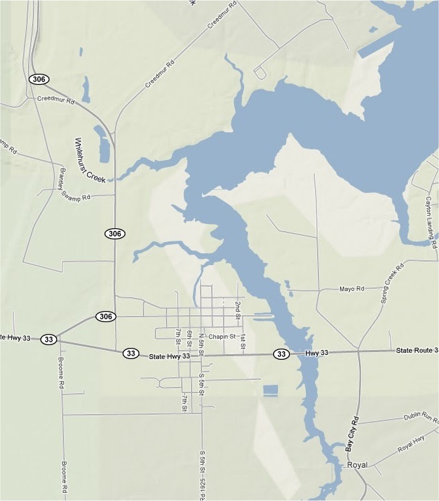
Map of Aurora, North Carolina, on South Creek that is upstream of the mighty Pamlico River. Click here or on the map for a larger representation of the Aurora area in eastern Beaufort County.
For the Municipality of Aurora's immediate benefit, to clear away fallen trees and massive debris from the roads, as per Beaufort County Emergency Management Director John Pack: "We will have sometime this afternoon five two-man chainsaw crews, with a team leader, heavy-equipment operator, and mechanic (13-man team), hailing from the mountains of North Carolina in Aurora clearing the roads to make way for emergency personnel and allow citizens of that battered town access to go and come."
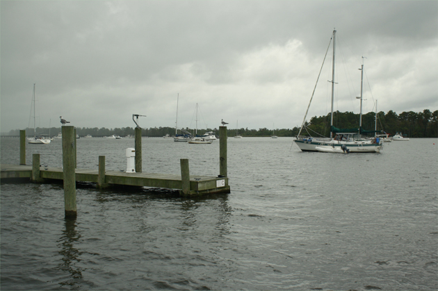
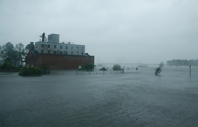
What a difference 20 hours of a day makes: Before the power of Hurricane Irene devastated Washington's waterfront, anchored ships await the inevitable: Above. The inevitable was more than most anyone expected: Below. photos by Stan Deatherage
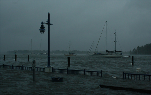
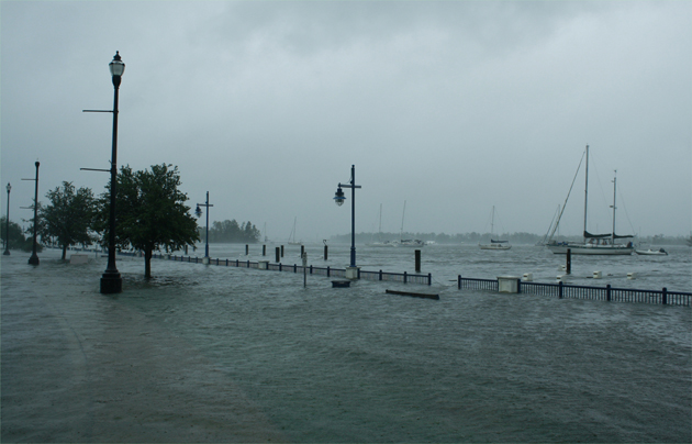
These were very moist conditions as the eye-wall is just on the edge of Beaufort County, and conditions were terrible here on Washington, North Carolina's waterfront. My camera did the best it could in bringing these shots to BCN. I have more: Above and below. photos by Stan Deatherage
To be continued in future editions.
Go Back
What may be the worst hurricane in the last 56 years (since Hurricane Hazel in 1954) has released its horrendous grip on the county I call home - Beaufort. I have endured as many of us have, but I do not remain unscathed.
Washington, North Carolina, looks like a war zone. Aurora, N.C., because of its geographic proximity to the ever-lingering eye wall (estimated at 40 to 45 miles wide, with the eye of this monster storm estimated from 30 to 35 miles wide) of Hurricane Irene, may well have taken Beaufort County's biggest hit. It is arguably, along with Belhaven, N.C., Beaufort County's lowest-lying municipality. Aurora's flood plain is about seven or eight feet. They took a storm surge of over 11 feet of Pamlico River, or more likely Pamlico Sound and Atlantic Ocean, water. If Aurora took three to four feet of water at its highest point, can you imagine how much water filled the lowest point. The culprit: Hurricane Irene's prevailing hurricane-force winds from the northeast hitting this low-lying hamlet that faces northeast.
The storm surge was so strong and the sustained winds so powerful in the eye wall that at one point four cottages - in a row - were seen floating down the Pamlico River. This information was reported to the Beaufort County Emergency Management Operation and Control Center by a resident who road out the storm from his home at Hickory Point (north from the battered Town of Aurora at the mouth of South Creek, where it empties into the Pamlico River).

For the Municipality of Aurora's immediate benefit, to clear away fallen trees and massive debris from the roads, as per Beaufort County Emergency Management Director John Pack: "We will have sometime this afternoon five two-man chainsaw crews, with a team leader, heavy-equipment operator, and mechanic (13-man team), hailing from the mountains of North Carolina in Aurora clearing the roads to make way for emergency personnel and allow citizens of that battered town access to go and come."
To be continued in future editions.

Comment

|
David Winstead said:
( August 28th, 2011 @ 8:28 pm )
|
| Hurricane Irene Update: Will Beaufort County dodge the bullet? | The Region | Did Beaufort County Dodge the Bullet? Not by a longshot |

Latest The Region
 |
Our office is currently monitoring an approaching weather system that will bring windy conditions, rain, and the potential for strong storms to our area tomorrow.
Published: Thursday, April 11th, 2024 @ 2:53 pm
By: Eastern NC NOW Staff
|
 |
The great misnomer for non Christians that the day Jesus Christ was executed by occupying Romans, celebrated by Christians as "Good" Friday, must be a paradox of ominous proportions.
Published: Saturday, March 30th, 2024 @ 7:52 pm
By: Stan Deatherage
|
 |
Republicans Bokhari and Driggs retain seats on city council.
Published: Tuesday, March 26th, 2024 @ 12:50 am
By: Carolina Journal
|
 |
Recently, Golden LEAF President, Chief Executive Officer Scott T. Hamilton sat down with Don Flow, Immediate Past Chair of the Golden LEAF Foundation Board of Directors via Zoom and filmed an episode of Critical Conversations.
Published: Monday, March 25th, 2024 @ 1:14 am
By: Eastern NC NOW Staff
|
 |
At the December Board meeting, the Golden LEAF Board of Directors awarded $5,540,432 in funding for 50 projects through the Food Distribution Assistance Program.
Published: Friday, March 1st, 2024 @ 11:31 pm
By: Eastern NC NOW Staff
|
 |
At the December Board meeting, the Golden LEAF Board of Directors awarded $650,000 to support two projects through the Open Grants Program and $3,080,000 to support five projects through the SITE Program.
Published: Wednesday, February 28th, 2024 @ 12:20 pm
By: Eastern NC NOW Staff
|
 |
Members of the North Carolina Rural Health Association (NCRHA) visited Washington, D.C., on Feb. 14, 2024, to meet with elected officials and advocate for policies to improve access to care in rural areas.
Published: Wednesday, February 28th, 2024 @ 12:51 am
By: Eastern NC NOW Staff
|
 |
Today, the Golden LEAF Board of Directors awarded $650,000 to support two projects through the Open Grants Program and $3,080,000 to support five projects through the SITE Program.
Published: Monday, February 26th, 2024 @ 10:04 am
By: Eastern NC NOW Staff
|
 |
WASHINGTON, N.C. –– The Cherry Run Solid Waste Collection Site, located at 2860 Cherry Run Road, Washington, NC 27889, will temporarily close for repairs on Monday, Nov. 20
Published: Saturday, February 24th, 2024 @ 11:32 am
By: Eastern NC NOW Staff
|


Home
Contact
About
Service Rates
Privacy Policy
Follow on Facebook
Subscribe to Newsletters
Rss Feed
Keywords
Eastern NC Now & ENC NOW © Copyright 1998-2024 All Rights Reserved.
